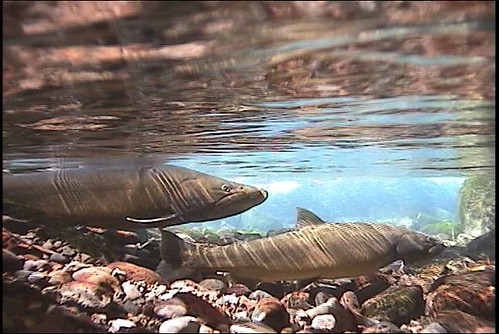
Bull trout spawn in a spring of the Middle Fork Willamette River. They were transferred from the McKenzie River to historic habitats in the Middle Fork. (U.S. Forest Service)
“We’re reintroducing the top predator back into the river ecosystem,” said Ray Rivera, the district fisheries biologist on the forest’s
McKenzie River Ranger District. “Their presence means two things to us. First, because bull trout are very sensitive to environmental changes compared to other salmonid fishes, their existence means the river’s water quality is excellent and the physical quality of their habitat is also good. Second, since bull trout are the top predator and they are doing well this means the overall ecosystem is doing well. Their presence is an excellent barometer of a river’s health.”
Bull trout, which are actually a char, are a groundwater dependent species. They require the coldest and cleanest water in order to fulfill their life cycle, with stream temperatures between 39.2 to 50 degrees for spawning. Optimal fry growth occurs between 39.2 to 40.1 degrees.
Within the entire McKenzie River sub-basin, only five small stream segments – a total of less than six miles – meet these requirements and all are found on the district. These cold temperatures exist because of groundwater discharge and are one reason bull trout were able to hang on in the McKenzie River sub-basin while other sub-populations in the Willamette River basin became extinct.
However, the McKenzie is no longer the only habitat for bull trout. Their range has increased due to the forest’s efforts in the last 16 years to restore their habitat and re-introduce bull trout to their historic territory in the Middle Fork of the Willamette River. Now these splendid, groundwater-dependent species are living in ecosystems that better reflect their historic range because of cold water springs like those found in the McKenzie.
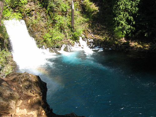
The McKenzie River at the base of Tamolitch Falls – meaning bucket in Chinook – flows during the spring runoff. Five miles downstream of Clear Lake, the falls was created when a lava flow dammed the McKenzie. (U.S. Forest Service)
Where does the cold groundwater come from? The source is young, porous basalt lava flows in the upper McKenzie River watershed.
“Volcanos erupted throughout the High Cascades region as recently as 1,500 years ago, leaving lava flows with a large network of underground fractures between the rocks,” said Gordon Grant, a fluvial geomorphologist with the agency’s
Pacific Northwest Research Station. “Precipitation filtering from the surface collects in those fractures, creating a gigantic hydrological sponge. The McKenzie and other High Cascade rivers are fed by groundwater that literally springs out of the earth.”
By September, many western rivers that rely on snowmelt runoff are reduced to a trickle. But groundwater keeps systems like the McKenzie River robust with water temperatures ranging around 48 to 53 degrees. The temperature of the cold water springs in the McKenzie range between 39 and 44 degrees.
These very cold groundwater-fed streams where the fish spawn also benefit the main stem river by providing abundant, cold summer flows for adult and sub-adult bull trout that can tolerate temperatures up to 68 degrees. For example, Olallie Creek, with a constant 40 degrees year-around, provides a large influx of cold water to the McKenzie in the summer and allows bull trout to dwell in the entire river.
Bull trout associated with glacial melt water are in trouble. As glaciers recede due to climate change the cold water supply becomes less robust and may eventually disappear entirely. However, bull trout associated with cooler groundwater sources will fare much better in a warming climate.
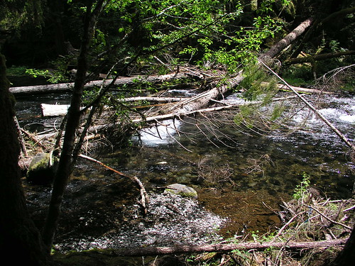
A bull trout habitat in the upper McKenzie River is one of five segments in the McKenzie where bull trout can spawn. Most of the wood in the photo is material added during a U.S. Forest Service restoration and enhancement project. (U.S. Forest Service)
- See more at: http://blogs.usda.gov/2013/11/14/range-of-bull-trout-in-oregons-mckenzie-river-indicates-improved-river-health/#sthash.9FcmvKZG.dpuf


